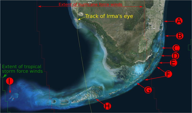
Sites available for post-hurricane surveys 2017
Florida (Irma)
Overview map (click to enlarge)
A) Sunny Isles: (all from 2014)
- Site A Zoomify, Zoomify with links to component images.
- Site B Zoomify, Zoomify with links to component images.
- Site C Zoomify, Zoomify with links to component images.
- Site D Zoomify, Zoomify with links to component images.
B) Emerald Reef:
- None of these are on line but we have multiple dates from 2005-2013.
C) Marker 14:
- Zoomify from 2012.
- There are other years as well, 2009, 2010 (I think multiple dates in 2010) but they are not online.
D) Ceasar Creek/Angel Creek:
- Evening Star grounding site on Anniversary Reef: Mosaic from 2005 (DV video camera), mosaic from 2006 (not on line), and mosaic from 2012 (GoPro HDV video camera)
- Pacific Reef Zoomify, Zoomify with links to component images from May 2015.
- Evan's Reef (off Broad Key) from 2014 (not available on line).
E) Carysfort:
- Carysfort large area (170 x 90 m) from Feb 2017.
- Carysfort normal high res site (~10x10m) embedded within the above, from the same day. (not available on line).
F) Williams/Miller Sites off Key Largo:
- Watson's Reef Zoomify from 2012
- Elbow site EL-1 zoomify | with links to component frames | with links to high-res stills | jpg from 2012.
- Elbow site EL-2 zoomify | with links to component frames | with links to high-res stills | jpg from 2012.
- Elbow site EL-4 and -5 zoomify from 2012.
- Horseshoe Reef zoomify and with links to high-res stills from 2009.
- Key Largo Dry Rocks from 2014 (not available on line).
- Grecian Rocks GR-1 from 2012 zoomify | with links to component frames | jpg.
- Grecian Rocks GR-2 from 2012 zoomify | PNG | JPG
- Grecian Rocks GR-2 from 2014 zoomify | with links to component frames | jpg.
- French Reef site FR-1 from 2012 zoomify | with links to component frames | with links to high-res stills | jpg.
- French Reef site FR-1 from 2014 zoomify | with links to component frames | jpg.
- French Reef site FR-2 from 2014 (not available on line).
- French Reef site FR-3 from 2012 zoomify | with links to component frames | with links to high-res stills | jpg.
- French Reef site FR-3 from 2014 (not available on line).
- Molasses Reef site ML-1 from 2012 (not available on line).
- Molasses Reef site ML-2 from 2012 (not available on line).
- Molasses Reef site ML-2 from 2014 (not available on line).
- Molasses Reef site ML-3 (the famous site that started it all!)
- Molasses Reef site ML-3 from 2005 zoomify (the famous site that started it all!)
- Molasses Reef site ML-3 from 2006 zoomify (following Dennis, Katrina, Rita, and Wilma)
- Molasses Reef site ML-3 from 2012 zoomify| JPG.
- Molasses Reef site ML-3 from 2014 zoomify | with links to component frames | jpg.
- Pickles Reef from 2012 (not available on line).
- Little Conch Reef from 2012 (not available on line).
- Conch Reef from 2012 (not available on line).
- Conch Reef from 2012 Joe Pawlik Muta sponge sites (not much coral) right near the Aquarius habitat.
G) Cheeca Rocks:
- Six 10 x 10m sites we did at Cheeca with Derek Manzello and co. REPEAT surveys May 2012, Aug 2014, Sep 2014, March 2015, Oct 2015, Aug 2016.
H) Big Pine:
- Two 10 x 10m sites we did at plots where Mote Marine Labs and the Field Museum of Natural History are outplanting corals.
- One large, 100 x 100m survey which includes the two smaller plots.
- Link to the page where these are posted.
I) DTNP:
- Williams/Miller sites (N=6) from 2013.
- CRMP Sites (N=8) from 2012 (not available on line) .
Puerto Rico (Irma and Jose)
Overview map (not available yet)
- Matthews grounding scar (about 100 x 40 m) from 2010 not available on line.
- Restoration plots within the Matthews, Egorov, Margara scars at various times 2013-2016.
- A few sites at Enrique Reef from summer 2015 (not available on line).
 ART GLEASON | Archive